current and historical maps
for Cambridgeshire
Since its foundation – as the Cambridge Ornithological Club in 1925 (and with membership strictly limited to twenty!) – the Cambridgeshire Bird Club has had a distinguished tradition of monitoring the county’s birds.

the avifaunas
There are two ‘modern’ avifaunas, both The Birds of Cambridgeshire – by David Lack (1934), and Peter Bircham (1989). Both of these are restricted to the pre-1972 old vice-county of Cambridgeshire, and exclude old Huntingdonshire and Peterborough. Lack wrote: “Not abundant, but a well distributed summer resident to the gardens and woods of the county, especially in the west, and rather scarce in the fen districts.” Bircham described the species as “A reasonably common summer resident” and noted that there were ten pairs in the CU Botanic Garden in 1982.
the ‘old vice-county’ atlases
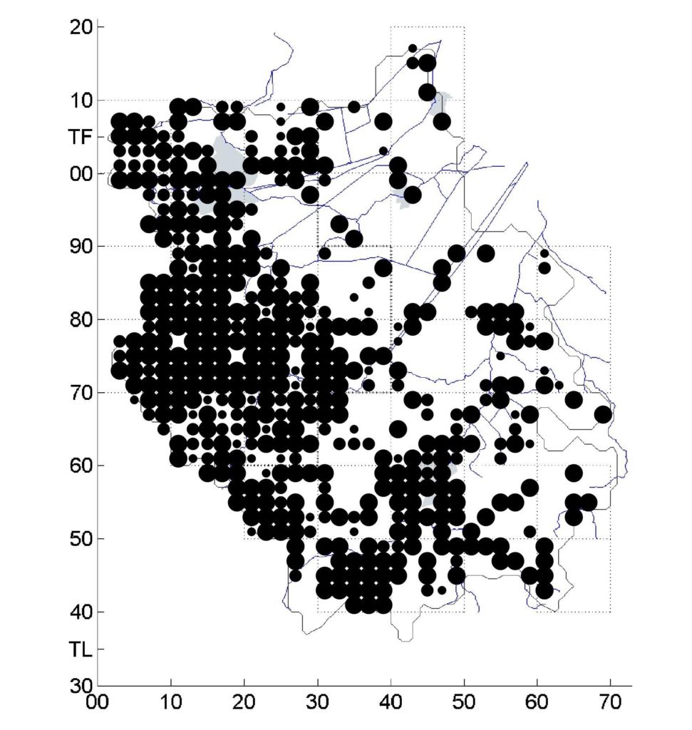
Both Old Huntingdonshire (in 1988) and Old Cambridgeshire (in 1994) saw the publication of progressive local atlases based on the tetrad (2km square) OS grid; this mapping unit had been pioneered by botanists. The two atlases have been combined in the composite map below. The large dots show confirmed breeding ; medium dots show probable breeding; and the small dots show possible breeding (just birds ‘present’).

These two old-county atlases are five years apart; it is possible that Cambridgeshire (the more thinly distributed bottom right part) was already showing the beginning of the decline which was to accelerate to 50% during 1995-2010, building up to the 70% decline which would be recorded 1970-2012. Fenland is probably under-recorded in both atlases, particularly in village gardens and/or churchyards; it is likely that few atlas recorders actually looked for the species in such places. It is equally possible that flycatchers were always very scarce in Fenland, which was underwater until the eighteenth century and still has no significant woodland.
[See the topography paragraph at the end of this section.]
the ‘new’ Bird Atlas
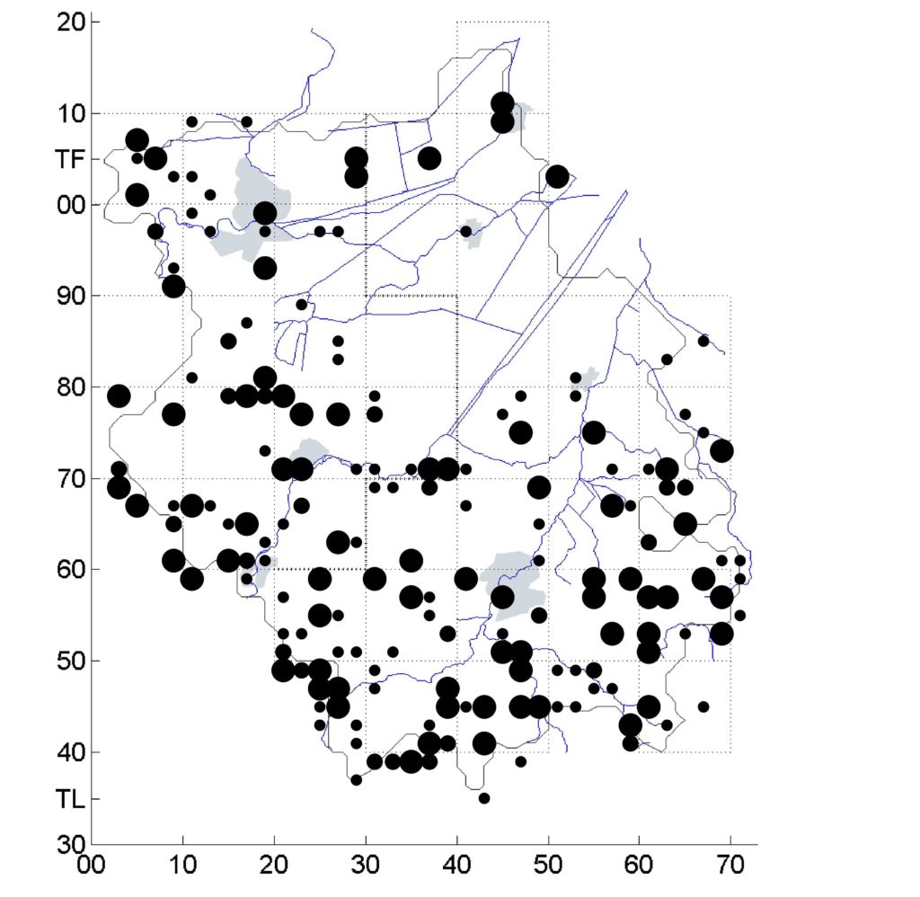
For the third BTO Atlas 2008-11, the Cambridgeshire Bird Club again recorded at the 2km tetrad level.

This atlas clearly shows a massive decline in range and density since the earlier vice-county atlases of 1978-92. It is also likely that it over-records flycatcher distribution. There are relatively too many tetrads with possible status (the smallest dot: a bird or birds present in suitable habitat on one occasion in one of the four years). Many of these probably do not suggest a true breeding pair. With the exception of the most open fenland, most of Cambridgeshire represents suitable habitat. At least some of these records will have been of passage birds at the beginning of the season (migration can carry on into June); or cases of noisy family parties in early July, which could have bred in nearby tetrads or even outside the county.
Spotted Flycatcher was first Red-listed in 2015 as a bird of increasing conservation concern in the UK.
the current position
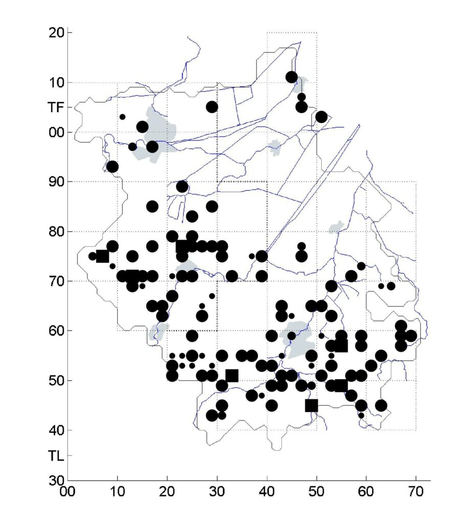
Fieldwork for the BTO geolocator project, which started in 2016, generated a lot of breeding records, and many new sites were located. The map below follows the normal dot-size conventions as above but, in addition, a solid square denotes a tetrad in which breeding was confirmed in all five years 2015-19.

However, the geolocator project in no way represented a full county survey. Fieldwork was limited to locating only a sufficient sample of pairs suitable for tagging. To minimise travel from Cambridge – and to avoid the A14 roadworks – fieldwork effort for the project was concentrated south of the OS 80 line (roughly level with Monks Wood/Ely). There were almost certainly more pairs to be found in the Old Huntingdonshire north-western quarter of the county.
over-estimates?
These days, very few tetrads will have more than one pair. With all atlas projects, whether early or recent, there is the question of transient (pop-up) pairs. In many cases in the Cambridgeshire historical atlases and also in the 2008-11 BTO Atlas, breeding was confirmed in a particular tetrad in only one of the years of the atlas survey. At an extreme level, what ends up being mapped in these traditional atlases as four confirmed pairs across four tetrads might in reality have been just a single pair in each year but in different tetrads.

Cambridgeshire tetrads by the highest number of years with birds present in the six years 2015-20. Fenland basin in pink. Map by Louise Bacon.
This map (Cambridge bottom right; Peterborough top left) shows in how many of the six years 2015–20 birds were found to be present (in all breeding categories). The smallest dot shows presence in just one single year (a pop-up, see above); a medium dot shows presence in two or three years; a large dot presence in four years; and a square denotes continuous presence in five or all six years – and, often, more than one pair in that tetrad.
In his 1934 Birds of Cambridgeshire David Lack wrote of flycatchers: “well distributed …. especially in the west, and rather scarce in the fen districts.” Given the limited study coverage north of Ely, the lack of records on the map above the TL80 coordinate – in the north-west (old Huntingdonshire) is unsurprising. But this also reinforces Lack’s clear association of flycatchers with higher ground and woodland. Flycatchers are largely absent from those parts of the county which are predominantly at or below sea-level within the fenland basin, shown here in pink. These are, of course, the areas which are under the most intensive arable cultivation and will have suffered the highest reductions in invertebrates. This pattern of distribution was, however, clearly apparent in the old county atlases. It is more likely that flycatchers were always very scarce in Fenland, which was mainly underwater until the eighteenth century and has never had any significant woodland. Where flycatchers do occur in the Fens it is within village gardens. Ridges or fen-islands of say 10m above sea-level (Wicken, Haddenham) are all that is required to make the difference.
